


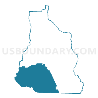
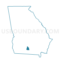
075NL - NEW LIFE BAPTIST Voting District, Cook County, Georgia
About
Outline

Summary
| Unique Area Identifier | 561000 |
| Name | 075NL - NEW LIFE BAPTIST Voting District |
| County | Cook County |
| State | Georgia |
| Area (square miles) | 54.38 |
| Land Area (square miles) | 53.05 |
| Water Area (square miles) | 1.33 |
| % of Land Area | 97.55 |
| % of Water Area | 2.45 |
| Latitude of the Internal Point | 31.08558650 |
| Longtitude of the Internal Point | -83.47943610 |
Maps

Graphs
Select a template below for downloading or customizing gragh for 075NL - NEW LIFE BAPTIST Voting District, Cook County, Georgia


Neighbors
Neighoring Voting District (by Name) Neighboring Voting District on the Map
- 0271571 - BARNEY Voting District, Brooks County, GA
- 0710015 - LEE Voting District, Colquitt County, GA
- 0710020 - ROBINSON Voting District, Colquitt County, GA
- 075C - CECIL Voting District, Cook County, GA
- 075RB - RIVERBEND Voting District, Cook County, GA
- 18501 - SHILOH FIRE STATION Voting District, Lowndes County, GA
- 18502 - NEWSOME ST CHURCH Voting District, Lowndes County, GA
Top 10 Neighboring County Subdivision (by Population) Neighboring County Subdivision on the Map
- Adel-Sparks CCD, Cook County, GA (15,061)
- Hahira CCD, Lowndes County, GA (14,844)
- Berlin-Ellenton CCD, Colquitt County, GA (3,449)
- Barney CCD, Brooks County, GA (911)
Top 10 Neighboring Place (by Population) Neighboring Place on the Map
Top 10 Neighboring Unified School District (by Population) Neighboring Unified School District on the Map
- Lowndes County School District, GA (54,715)
- Colquitt County School District, GA (45,498)
- Cook County School District, GA (17,212)
- Brooks County School District, GA (16,243)
Top 10 Neighboring State Legislative District Lower Chamber (by Population) Neighboring State Legislative District Lower Chamber on the Map
- State House District 176, GA (56,994)
- State House District 170, GA (51,371)
- State House District 174, GA (48,740)
Top 10 Neighboring State Legislative District Upper Chamber (by Population) Neighboring State Legislative District Upper Chamber on the Map
Top 10 Neighboring 111th Congressional District (by Population) Neighboring 111th Congressional District on the Map
- Congressional District 1, GA (722,068)
- Congressional District 8, GA (715,599)
- Congressional District 2, GA (631,973)
Top 10 Neighboring Census Tract (by Population) Neighboring Census Tract on the Map
- Census Tract 102.02, Lowndes County, GA (11,096)
- Census Tract 9603, Brooks County, GA (5,801)
- Census Tract 9604, Cook County, GA (4,700)
- Census Tract 9602, Cook County, GA (4,002)
- Census Tract 102.01, Lowndes County, GA (3,748)
- Census Tract 9705, Colquitt County, GA (3,449)